


INVITED RESEARCHERS
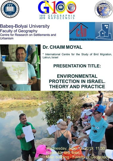
On June 12, 2019, two representatives of the international academic community will be hosted by the Centre for Research on Settlements and Urbanism, Department of Human Geography and Tourism, Faculty of Geography in Cluj-Napoca:
Academician Prof. Dr. BOJIE FU - Vice-president of the International Geographical Union, President of the Geographical Society of China, General Director of the Department of Earth Sciences, National Natural Science Foundation of China and Director of the Division of Geosciences of the Chinese Academy of Sciences.
Dr. CHAIM MOYAL - Researcher, affiliated at the International Centre for the Study of Bird Migration, Latrun, Israel.
On this occasion, both of our invited scholars will give lectures on current issues related to urbanization, ecological restorationa and environmental protection.
BOOK LAUNCH
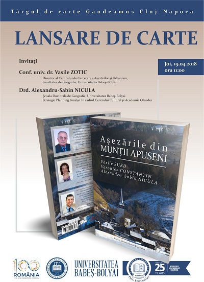
On April 19, 2018, the GAUDEAMUS Book Fair in Cluj-Napoca hosts the book launch of the volume entitled Settlements in the Apuseni Mountains (RO: Așezările din MUNȚII APUSENI) [Book in Romanian], authored by Prof. dr. Vasile SURD, Dr Veronica CONSTANTIN and Alexandru-Sabin NICULA, PhD Student. This work was supported by the Center for Research on Settlements and Urbanism, Faculty of Geography of the Babeş-Bolyai University in Cluj-Napoca.
Prof. Dr Vasile ZOTIC will speak on behalf of the Center for Research on Settlements and Urbanism, whilst Alexandru-Sabin NICULA, PhD Student, on behalf of authors [VIDEO].
SETTLEMENTS IN THE APUSENI MOUNTAINS
SURD Vasile, CONSTANTIN Veronica, NICULA Alexandru-Sabin
Presa Universitară Clujeană, Cluj-Napoca, 2017
The Apuseni Mountains represent the most heavily populated sector of the Romanian Carpathians. These are bordered by Mureș River Valley in the South and Barcău River Valley in the North. In the West, the limit is given by the West Hills and Plain, and in the East, the Mureș River Valley separates them from the Târnavelor Plateau. Within these boundaries, there are 171 administrative-territorial units (ATUs), of which 154 are rural (communes) and 17 urban (cities and towns, comprising 1274 settlements). The Apuseni Mountains cover a surface of 15,698.6 km2, representing 6.58% of the Romanian territory. With about 564,882 individuals (according to the National Census in 2011), this mountainous area holds 3.25% of the national total population. The Apuseni Mountains are the lowest mountains in Romania, with a maximum height of 1848 m in the Bihor Mountains (central sector). The general population density reaches 45 inhabitants/ km2 (85 inhabitants/ km2 average density at national level).
The average settlement size is of 518 people. About 62% of inhabitants live in rural areas, while about 38% of them inhabit the urban areas. The residents of the central mountainous sector are known as moți (motzi) due to their long-haired hair, worn in a tail, up until the last century. The other locals, located in the valleys of Criş, Arieșul Mijlociu and Ampoi rivers are known as mocani (mountain people, herders). Most of the settlements were first attested in the 12th century, although the mining exploitations in the central sector (Roşia Montană, Abrud, Zlatna, Baia de Arieş) indicate uninterrupted habitation ever since the Dacian-Roman period (1st and 2nd centuries, AD). The essential feature of these mountains lies in the existence of small, scattered villages, called "crânguri", whose population rarely exceeds 50 inhabitants. Only the villages located along the river valleys have larger populations and became administrative centres due to the more favourable communication potential. In the central mountain area of Arieş River valley, also known as the Land of Moți (RO: Țara Moților), the average number of villages in a commune is of over 20, yet the total population per commune not exceeding 2000 inhabitants.For instance, Vidra commune located in the Arieşul Mic river basin consists of 39 villages, but the total population is of just 1691 inhabitants (2011). In Apuseni Mountains we also find permanent settlements located at the highest altitude in Romania (1300m), namely Măguri village (Măguri-Răcătău commune, Cluj County). Most of the settlements are spatially concentrated at an average height of 200-600 m, dominantly on slopes with favourable natural thermal potential (East, South, West, South-East, South-West). Most settlements have irregular shapes; they are unstructured and scattered, with chaotic geometric textures.
The scattered settlements located in the upper basin of Arieş river, namely "crânguri", are more recently established (18th and 19th centuries) as a result of the relocation of the population from the villages along the valleys. Most of them bear the names of the first families who settled here by deforesting forests (Rus- Rusești, Culda-Culdeşti, Matiş-Matişeşti, Nicoară-Nicoreşti, etc.).
The process of settlement scattering was mostly determined by the poor quality of the soil. Therefore, in order to meet the minimum food needs per person, they had to agriculturally exploit areas 5 times larger than in the lowlands.
At altitudes over 800-1000 m, there are few temporary settlements, populated only in summer for pasture grazing in the high grasslands. In the last century, this type of settlement was very frequent and active, being the main economic support of the permanent villages located along the valleys.
The economic and functional profile of settlements reveals mainly primary activities, namely animal husbandry (mostly cattle) and illicit logging, sometimes in collusion with government authorities. The most extensive deforested areas in the last 25 years are located in the central area of the Apuseni Mountains (Vlădeasa, Bihor, Muntele Mare) mostly covered by coniferous forests.
Another defining feature of the Apuseni Mountains is the existence of the richest gold-silver, copper and uranium deposits in Romania. There used to be 11 mining areas where most of the male population was employed.
Between 1952 and 1956, the uranium deposit located in the central sector of Băița - Bihor was intensively exploited by the Soviet occupation forces.
For instance, Ştei Village, with a population of about 700 people in 1948, reached almost 10,000 inhabitants in 1856, being decreed town in the same year, as a result of the intensification of uranium exploitation, a process that required a high number working individuals.
Except for the copper exploitations from Roşia - Poieni mine in Alba County, mining activities, including the gold exploitations at Roşia Montană, ceased in recent years due to the local and national political and economic interests and agreements.
Over the last 25 years, most settlements here have developed their tertiary functions mainly by increasing the number of administrative staff in the town halls and other public and service-related institutions (schools, social services, security, retail, etc.).
All urban settlements have changed their economic profile switching to services, the traditional industries being no longer active.
Based on the Local Human Development Index (LHDI) the general development level of settlements was calculated. Except for the larger urban centres located at the mountain periphery (Alba Iulia, Turda, Zalău), most of the settlements prove to have a severely low level of development. Localities with less than 50 inhabitants were not considered since their natural disappearance is imminent.
The number of the employed population is of 250,647 people, representing 31% of the total mountain population. In rural areas, the share of the employed population is higher than in urban areas (44% compared to 38%). If we exclude the 17 urban centres that have 249,334 inhabitants, a rural settlement has an average of 325 inhabitants, which is 50% less compared to the average size of rural settlements in Romania (735 inhabitants).
In the last 25 years, a series of specific facilities with tertiary functions such as monasteries, motels and tourist villages have been established and developed. Similarly, private villas were hastily built, especially in the areas acknowledged for their health-care features and suitable for practising winter sports (Boga – Bihor county, Vârtop and Nucet – Bihor county, Beliş - Fântânele – Cluj county).
All these 171 settlements create specific systemic settlement systems. We distinguished 6 categories, of which 2 are rural and 4 are urban. Thus, rural systems are dominant, having the main villages (the communal centres) as their convergence nuclei. Some of the communal centres are better developed in terms of services, thus becoming systemic centres of supra-communal polarization, attracting population from the nearby settlements (Gilău – Cluj county, Dobreşti – Bihor county, Albac – Alba county).
Also, 4 types of urban systemic centres were identified, namely: local, zonal, inter-county and county. Local urban centres include small urban centres such as Baia de Arieş, Nucet, Vașcău, Ştei and Geoagiu. Among the zonal ones, we mention Aiud, Huedin, Aleşd, Beiuş, Câmpeni, Brad, Lipova. The inter-county centre of influence is represented by Turda town in Cluj County, which is in competition with the towns of Luduş in Mureș County and Aiud town from Alba County. The point with null attraction between Cluj-Napoca and Turda is found at about 6 km of Turda on DN1 - E60 route. The urban centres with county polarization are represented by Alba Iulia and Zalău, county capital cities, whose influence is roughly limited to their administrative area.
The western part of the Apuseni Mountains is polarized by the cities of Arad and Oradea whilst the southern one by Deva city. Cities ranked as provincial centres, namely Cluj-Napoca and Timișoara, exert their influence from outside. Therefore, the northern sector is polarized by Cluj-Napoca and the southern one by Timișoara. The mountain range is dominated by highly dispersed small settlements and extremely undeveloped, lacking in any urban functions.
As in the past, the Apuseni Mountains are still functioning today as a "drain" system, constantly losing people and resources, the input processes being fragile and circumstantial. The population decline is generalized [full text].
GENERAL ELECTION CCAU
In January 2016, general elections are held to appoint the new administrative and scientific board of the Centre for Research on Settlements and Urbanism.
Schedule: January 19 2016 – 1st round; January 26 2016 – 2nd round.
Candidates: Assoc. Prof.Dr Vasile ZOTIC, a founding member of CCAU, for the position of Director.
In the period of 11-17 May 2015, the Centre for Research on Settlements and Urbanism organized the study field trip for the 1st year Geography students from the Faculty of Geography, Babeș-Bolyai in Cluj-Napoca. The proposed itinerary: Cluj-Napoca - Iara - Buru - Baia de Arieș - Câmpeni - Gârda de Sus - Peștera Ghețarul Scărișoara - Roșia Montană - Abrud - Brad - Țebea - Deva - Simeria - Hațeg - Baru Mare - Mănăstirea Prislop - Hunedoara - Petroșani - Mănăstirea Lainici - Tg. Jiu - Mănăstirea Tismana - Baia de Aramă - Băile Herculane - Orșova - Drobeta Tr. Severin - Belgad - Oravița - Bozovici - Caransebeș - Oțelu Roșu - Hațeg - Orăștie - Alba Iulia - Cluj-Napoca See more here.
In the period 1-7 August 2014, the Centre for Research on Settlements and Urbanism organized the second Mountain Expedition in Rodna Mountains See more here.
From 21 to 28 July 2014, we are hosting Dr Ewa KACPRZAK and Dr Barbara MAĆKIEWICZ, who are visiting researchers from Adam Mickiewicz University, Institute of Socio-Economic Geography and Spatial Management, Poznan, Poland. They will also lecture a presentation on the topic: Ecotourism in Poland. This presentation is scheduled for Wednesday, July 22, 2014, at 10 o'clock at the Centre for Research on Settlements and Urbanism See more here.
From 16 to 23 May 2014, we are hosting Prof. dr. Per Åke Nilsson (Sweden) who is visiting our centre for research purposes. During his one-week stay he will also lecture a presentation on the subject of Heritagization. This presentation is scheduled on Wednesday, May 21, 2014, at 10 o'clock at the Centre for Research on Settlements and Urbanism See more here.
In 2014, Centre for Research on Settlements and Urbanism organizes the 6th edition of the International Conference on Rural Space and Local Development, with the theme: Peripheral Rural Areas between Certain Existence and Uncertain Developement See more here.
In 2012, CCAU organized the 5th edition of the International Conference Rural Space and Local Development, with the theme: Rural Mountain Areas. Experience, Preservation, Trends and Future Challenges See more here.
Since 2010, The Centre for Research on Settlements and Urbanism has been publishing its own biannual journal entitled Journal of Settlements and Spatial Planning (JSSP), edited exclusively in English See more here.
In 2010, CCAU organized the 4th edition of the International Conference Rural Space and Local Development, with the theme: Regeneration of the Rural Space See more here.